![](/images/other/stat-length.png)
![Trail Mountain bike La Baume-de-Transit - Circuit Vert n°3 les Balmes - Photo](https://media.geolcdn.com/t/1900/400/987d802c-aebd-4bf1-a3af-671d0a565a46.png&format=pjpeg&maxdim=2)
Circuit Vert n°3 les Balmes
lespoulpes
User
![Length](/images/other/stat-length.png)
![Max alt](https://static1.geolcdn.com/siteimages/upload/files/1508320355ic_sort_altitude_max_24dp.png)
![Uphill gradient](https://static1.geolcdn.com/siteimages/upload/files/1508320355ic_sort_den_pos_24dp.png)
![Km-Effort](/images/other/stat-length.png)
![Min alt](https://static1.geolcdn.com/siteimages/upload/files/1508320355ic_sort_altitude_min_24dp.png)
![Downhill gradient](https://static1.geolcdn.com/siteimages/upload/files/1508320355ic_sort_den_neg_24dp.png)
![Boucle](https://static1.geolcdn.com/siteimages/upload/files/16400158638029165_repeat_loop_refresh_sync_direction_icon.png)
![Mountain bike](https://static1.geolcdn.com/sitytour/trail-icons/202.png)
1h13
Difficulty : Very easy
![Scan this QR Code to open this trail in the SityTrail application](https://capi.geolives.com/qq0zvz2zws4bq2lad0pu/sitytour/trails/2437621/qr.png?size=200)
FREE GPS app for hiking
About
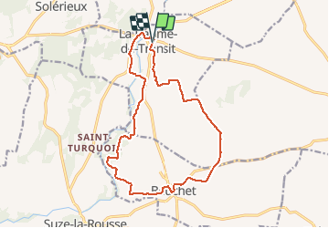
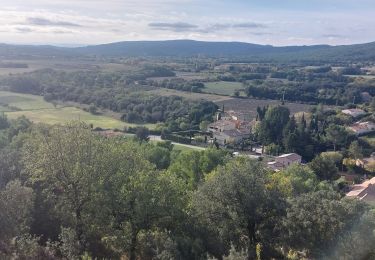
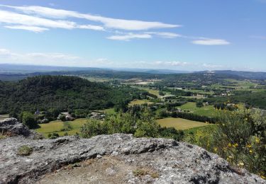
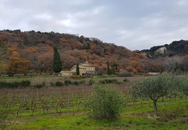
Trail Mountain bike of 16.4 km to be discovered at Auvergne-Rhône-Alpes, Drôme, La Baume-de-Transit. This trail is proposed by lespoulpes.
Description
3 - TRÈS FACILE | 16 km | 76 m déniv. | 1h45 Départ : La Baume-de-Transit
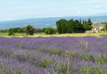
À la découverte des sites remarquables tels que les vieux villages de La Baume- de-Transit et de Bouchet, avec château, abbaye cistercienne et église Romane, vous emprunterez de beaux chemins qui vous feront traverser les vignobles de la région.
DÉPART : Place de la mairie (point d’eau). Passer sous le porche à gauche, traverser le vieux village et à droite rejoindre la D117, puis tourner à gauche. Attention voitures !
1. Prendre à gauche une petite route, à une bifurcation, tourner à gauche. Passer une passerelle et un sentier ludique. Rejoindre la D141. Attention voitures !
1,1 km
2. Tourner à droite, puis à 600 m virer à droite pour emprunter plus loin un chemin bucolique qui conduit à travers des vignes.
2,3 km
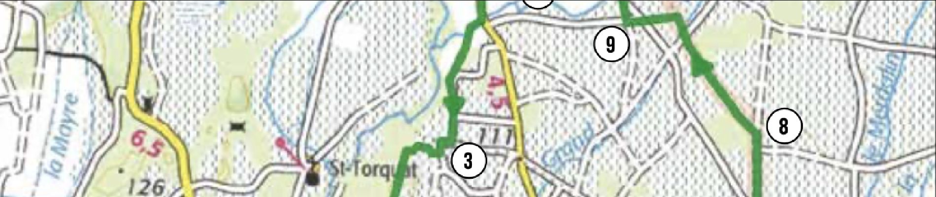
3. Prendre à droite en longeant les vignes, puis tourner à gauche à une habitation. Suivre le balisage en empruntant de beaux chemins jusqu'aux Esparants (alt. 118 m).
4,1 km
4. Tourner à droite. Suivre le chemin principal jusqu'à une petite route, puis tourner à gauche. Attention voitures ! Un peu plus loin, un aller-retour de 200 m permet de voir un ancien lavoir à la belle architecture.
5,3 km
5. Emprunter à droite une petite route pittoresque, passer devant de beaux oliviers, puis rejoindre à droite le Coudair (alt. 102 m).
7km
6. Rejoindre la D141. Tourner à droite, puis à gauche (point d’eau). Passer à Bouchet (alt. 97 m), puis admirer l'église Romane et l'abbaye cistercienne pour atteindre la Chapelle (alt. 103 m). Attention voitures !
8,4 km
7. Tourner à droite, puis à une croix à droite, passer à "Fontpeirolles ". Plus loin, à gauche, un chemin mène à la route. Couper en face pour emprunter un autre chemin entre les vignes. Attention voitures !
9,1 km
8. À une patte d'oie, prendre le chemin à gauche longeant un bois. Toujours tout droit, atteindre une bifurcation. Prendre à gauche.
11,7 km
9. Tourner à droite sur un chemin. Continuer sur une petite route, puis à gauche. Atteindre la maison " des Brunes" et tourner à droite. Attention voitures !
13,4 km
10. Quitter la route en vous engagant sur un chemin à droite. Rejoindre une petite route. Tourner à gauche et suivre un beau chemin à droite.
14,7 km
11. À la bifurcation, tourner à gauche pour rejoindre un rond-point, puis rejoindre le long des platanes à droite l'arrivée. Attention voitures !
16,3 km
ARRIVÉE : Place de la mairie (point d’eau).
16 km
Positioning
Comments
Trails nearby
![Trail Walking Montségur-sur-Lauzon - Bassin des druides. Montségur-lauzon - Photo](https://media.geolcdn.com/t/375/260/ext.jpg?maxdim=2&url=https%3A%2F%2Fservices.sitytrail.com%2FGeolivesWS%2FDownloadMedia.ashx%3FTrailID%3D892897%26Media%3Dfix__20180124152347.jpg)
![Walking Walking](https://static1.geolcdn.com/sitytour/trail-icons/101.png)
Walking
![](/images/other/stat-length.png)
![](https://static1.geolcdn.com/siteimages/upload/files/16400158638029165_repeat_loop_refresh_sync_direction_icon.png)
![Trail Walking Suze-la-Rousse - soleirieu - Photo](https://media.geolcdn.com/t/375/260/ext.jpg?maxdim=2&url=https%3A%2F%2Fstatic1.geolcdn.com%2Fsiteimages%2Fupload%2Ffiles%2F1553511878bg_sport_marche.png)
![Walking Walking](https://static1.geolcdn.com/sitytour/trail-icons/101.png)
Walking
![](/images/other/stat-length.png)
![](https://static1.geolcdn.com/siteimages/upload/files/16400158638029165_repeat_loop_refresh_sync_direction_icon.png)
![Trail Walking Clansayes - 2022-06-24_19h24m07_Clansayes Le Rouvergue 11km.gpx.xml - Photo](https://media.geolcdn.com/t/375/260/89c952dc-9c57-4311-93c9-63263f0349ef.jpg&format=jpg&maxdim=2)
![Walking Walking](https://static1.geolcdn.com/sitytour/trail-icons/101.png)
Walking
![](/images/other/stat-length.png)
![](https://static1.geolcdn.com/siteimages/upload/files/16400158638029165_repeat_loop_refresh_sync_direction_icon.png)
![Trail Walking Clansayes - SityTrail - 2656269 - chantemerle-clansayes-15km - Photo](https://media.geolcdn.com/t/375/260/10944c4f-f60a-41d6-ab1f-e2a3431a6612.jpg&format=jpg&maxdim=2)
![Walking Walking](https://static1.geolcdn.com/sitytour/trail-icons/101.png)
Walking
![](/images/other/stat-length.png)
![](https://static1.geolcdn.com/siteimages/upload/files/16400158638029165_repeat_loop_refresh_sync_direction_icon.png)
![Trail Walking Clansayes - Clansayes Montsègur-sur-Lauzon 18km. - Photo](https://media.geolcdn.com/t/375/260/5c78650a-5d36-4e02-ae94-f71e1d1beacc.jpg&format=jpg&maxdim=2)
![Walking Walking](https://static1.geolcdn.com/sitytour/trail-icons/101.png)
Walking
![](/images/other/stat-length.png)
![](https://static1.geolcdn.com/siteimages/upload/files/16400158638029165_repeat_loop_refresh_sync_direction_icon.png)
![Trail Walking Clansayes - Clansayes : Notre Dame de Toronne 9,5km. - Photo](https://media.geolcdn.com/t/375/260/3e074637-a909-4e30-981f-8312e72c1c41.jpg&format=jpg&maxdim=2)
![Walking Walking](https://static1.geolcdn.com/sitytour/trail-icons/101.png)
Walking
![](/images/other/stat-length.png)
![](https://static1.geolcdn.com/siteimages/upload/files/16400158638029165_repeat_loop_refresh_sync_direction_icon.png)
![Trail Walking Clansayes - Clansayes Côte du Serre Chapelle Toronne 7km - Photo](https://media.geolcdn.com/t/375/260/7e66ea7d-9394-4244-93cf-3e15e2674b24.jpg&format=jpg&maxdim=2)
![Walking Walking](https://static1.geolcdn.com/sitytour/trail-icons/101.png)
Walking
![](/images/other/stat-length.png)
![](https://static1.geolcdn.com/siteimages/upload/files/16400158638029165_repeat_loop_refresh_sync_direction_icon.png)
![Trail Walking Clansayes - Clansayes - Photo](https://media.geolcdn.com/t/375/260/f4c6dbe4-70cc-4cbf-b643-4ce5d4d43ccd.jpg&format=jpg&maxdim=2)
![Walking Walking](https://static1.geolcdn.com/sitytour/trail-icons/101.png)
Walking
![](/images/other/stat-length.png)
![](https://static1.geolcdn.com/siteimages/upload/files/16400158638029165_repeat_loop_refresh_sync_direction_icon.png)
![Trail Walking Clansayes - Les jumelles de Rozet - Photo](https://media.geolcdn.com/t/375/260/ext.jpg?maxdim=2&url=https%3A%2F%2Fstatic1.geolcdn.com%2Fsiteimages%2Fupload%2Ffiles%2F1553511878bg_sport_marche.png)
![Walking Walking](https://static1.geolcdn.com/sitytour/trail-icons/101.png)
Walking
![](/images/other/stat-length.png)
![](https://static1.geolcdn.com/siteimages/upload/files/16400158638029165_repeat_loop_refresh_sync_direction_icon.png)